Showing 12 items matching ‘laurel hill’
-
 Eltham District Historical Society Inc
Document - Folder, Murray, John and Mary
... Laurel Hill Farm Eltham..., September 1994 [history of family and Laurel Hill farm]. Photograph..., September 1994 [history of family and Laurel Hill farm]. Photograph ...John Contents Letter: J N Murray to Eltham Historical Society, 16 August 1970. Requests information about the Murray family. Letter: J N Murray to B Wadeson [?Eltham Shire Council], 24 March 1974. Requests information about the Murray family. Letter: Brian R Smyth solicitor to Eltham Historical Society, 31 August 1993: Re estate of J E Murray and contents of buildings and site. Letter: Eltham Historical Society to Bryan Smyth, 7 September 1993: Re contents of buildings and site, in association of Shire of Diamond Valley. Newspaper article: "Back when the land was theirs", Diamond Valley News, 28 September 1992. Interview of James (Jim) Murray about his family and farm. Text: "A development philosophy for 'Murray's", Eltham North", by John R Sabine, September 1994 [history of family and Laurel Hill farm]. Photograph: Grave stone of John Murray, Mary Murray, Thomas Drain and Mary Ellen Drain. Text: "Murray" by A Sheehan, no date. History of Murray family. Text: John Wright Murray", no author, no date: History of John Wright Murray. Newspaper clippings, A4 photocopies, etcjohn wright murray, mary murray nee sweeney, thomas sweeney, diamond creek, zig zag road, eltham cemetery, johnnie murray, james murray, eltham north reserve, bridget sweeney nee coleman, bridget cecilia murray, michael (mick) dillon, hamilton drain, mary ellen drain, thomas drain, john murray, patrick murray, thomas murray, william murray, laurel hill farm eltham, patrick bernard murray, elizabeth josephine tooher, john meyler bagot, thomas vincent murray, margaret gleeson, william louis murray, james augustine murray, julia agnes brennan, william johnston, isaac rooks, john r sabine, murray's bridge, wattletree road eltham, zig zag road eltham, larry brennan, evelyn arms hotel eltham -
 Eltham District Historical Society Inc
Photograph, Tess Justine (Nillumbik Shire Council), Construction work on replacement of Murray's Bridge over the Diamond Creek, Eltham North, 31 Mar 2022
... ‘Laurel Hill’... son John in 1873. The farm was known as ‘Laurel Hill’. John... son John in 1873. The farm was known as ‘Laurel Hill’. John ...Construction work on replacement of Murray's Bridge over the Diamond Creek on the Diamond Creek Trail Mary (Sweeney) Murray and John Wright Murray selected 80 acres, Lot C Section 16 and Lot 5 Section 17 Parish of Nillumbik, under an occupation license in 1866. John died in 1867 and freehold was granted to his son John in 1873. The farm was known as ‘Laurel Hill’. John Junior was an Eltham Shire councillor and sometime president from 1887 up until 1897. He added Lot A Section 16 to the farm in ca1888. John and his younger brother James arranged to rent/purchase Lot B Section 17, across Diamond Creek to the west, in ca1900. It appears that John and James farmed separately for a few years, with a new homestead built for James ad family on the high point of Lot B Section 17 in ca1910. John sold off Lot 5 Section 17 in 1912. When John died in 1912 James took over the land on both sides of the Diamond Creek. The old homestead on the west side of the Creek disappeared. A farm bridge over Diamond Creek from this period may have been located close to the northern boundary of the farm. John Langlands, owner of the farm known as ‘Ihurst’ on the west side of Diamond Creek to the south of the Murray’s land, died in 1907. In 1909 his land was then subdivided into 100 lots to become the ‘Glen Park Estate’. Other similar subdivisions of nineteenth century farms around Eltham in this period included the ‘Franktonia (or Beard’s) Estate’ to the northeast and ‘Bonsack’s Estate’ between Eltham and Greensborough. Soon after the opening of the railway extension line from Eltham to Hurstbridge in 1912, Glen Park and nearby residents including James Murray agitated for a railway station or siding to be located half-way between Eltham and Hurstbridge, so that the Glen Park residents who used the railway daily did not have to walk into the Eltham or Hurstbridge stations. Some believed Coleman’s Corner (opposite Edendale Farm) was an appropriate spot for the platform. James Murray was among those who thought the railway should be located on his land, closer to half-way between Eltham and Hurstbridge stations. The Railways Commissioners warned that the locals would have to fund these works themselves. The Glen Park Estate residents initially had difficulty accessing Eltham by road, with only an old low-level bridge over Diamond Creek at the south end of their estate. A new timber trestle bridge across the creek, now on Wattletree Road, was opened in 1915. Road access to the north was gained in 1927 when the new Murray’s Road, which crossed the Murray’s land, was built. Residents continued to agitate for a Glen Park station. By 1926 the Railways Commissioners’ preferred site was on the Murray’s land. They arranged an estimate of cost of a full-length platform. The estimate was too much for the locals, who in 1928 argued unsuccessfully for a shorter and hence cheaper platform. By 1929 Murray had agreed to donate the land, but the locals would still have to fund the works. Murray decided, unilaterally it would appear, to commence work on a timber trestle road bridge over Diamond Creek to link the new Murray Road to the proposed station. Late in 1929 he stopped work on the bridge, for reasons unknown, but started work again and completed the bridge in 1931. There is no further newspaper evidence of the campaign for the Glen Park station until 1939, when Murray and another local, Mr Maxwell, met the Railways Commissioner. The Glen Park locale now included 45 homes on the west side of the creek and 20 on the Eltham side. Most of the residents used the train every day. The Commissioner remained adamant that only a full-length platform could be built for safety reasons. It appears the campaign dissolved at this point. The increasing move to cars may have had an impact. There is no evidence of Murray’s bridge ever being connected to Murray’s Road, or of it having wide use for any purpose by locals. James Murray died in 1947 and the farm was taken over by his son James (Jim). Jim started to sell off parts of the farm in the 1980s, retaining a few acres around the ca1910 homestead and building a new house there. Recreation reserves were established along the creek. In ca1990 Murray’s bridge was renovated with steel girders as part of a bike/pedestrian path in the reserve. The old farmhouse was demolished in ca2014. Born digital image (5)diamond creek (creek), diamond creek trail, murrays bridge, ‘laurel hill’, john wright murray, mary (sweeney) murra, john murray jnr, james murray, john langlands, ‘ihurst’, ‘glen park estate’, beard's estate, franktonia, bonsack's estate, glen park estate, glen park railway station -
 Eltham District Historical Society Inc
Photograph, Tess Justine (Nillumbik Shire Council), Murray's Bridge over the Diamond Creek, Eltham North, 19 Feb 2022
... ‘Laurel Hill’... son John in 1873. The farm was known as ‘Laurel Hill’. John... son John in 1873. The farm was known as ‘Laurel Hill’. John ...Murray's Bridge over the Diamond Creek on the Diamond Creek Trail just prior to demolition and replacement with a new steel bridge. Heritage advice obtained by Nillumbik Shire Council, following a suggestion by the Eltham District Historical Society (EDHS), is that the original bridge appears to have been a simplified version of the Country Roads Board’s (CRB) standard timber bridge design of the early-to-mid 1920s. In c1990 Murray’s bridge was renovated with three recycled steel girders as part of a bike/pedestrian path in the reserve. During these alterations many parts of the bridge were removed, and some were replaced. Heritage advice indicates the condition of Murray’s bridge is poor. The remaining original parts are all in poor condition, with severe weathering, splitting and rot, especially to the stringers retained on the bridge. Heritage advice is that Murray’s Bridge does not have sufficient significance in the cultural history of the Nillumbik area to warrant inclusion in the Nillumbik Shire Heritage Overlay and also does not have sufficient significance as a rare survivor to warrant inclusion in the Nillumbik Shire Heritage Overlay. There are no indications in the historical record that this site was individually important to the cultural history of this area. EDHS is comfortable with the heritage advice provided to Council and has worked closely on this project with Council. EDHS has suggested some of the removed timbers be used in the vicinity of the bridge for landscaping and possibly seating, so as to retain these remnants close to the site of the original bridge, which is the last old timber bridge along the lower reaches of the Diamond Creek. Mary (Sweeney) Murray and John Wright Murray selected 80 acres, Lot C Section 16 and Lot 5 Section 17 Parish of Nillumbik, under an occupation license in 1866. John died in 1867 and freehold was granted to his son John in 1873. The farm was known as ‘Laurel Hill’. John Junior was an Eltham Shire councillor and sometime president from 1887 up until 1897. He added Lot A Section 16 to the farm in ca1888. John and his younger brother James arranged to rent/purchase Lot B Section 17, across Diamond Creek to the west, in ca1900. It appears that John and James farmed separately for a few years, with a new homestead built for James ad family on the high point of Lot B Section 17 in ca1910. John sold off Lot 5 Section 17 in 1912. When John died in 1912 James took over the land on both sides of the Diamond Creek. The old homestead on the west side of the Creek disappeared. A farm bridge over Diamond Creek from this period may have been located close to the northern boundary of the farm. John Langlands, owner of the farm known as ‘Ihurst’ on the west side of Diamond Creek to the south of the Murray’s land, died in 1907. In 1909 his land was then subdivided into 100 lots to become the ‘Glen Park Estate’. Other similar subdivisions of nineteenth century farms around Eltham in this period included the ‘Franktonia (or Beard’s) Estate’ to the northeast and ‘Bonsack’s Estate’ between Eltham and Greensborough. Soon after the opening of the railway extension line from Eltham to Hurstbridge in 1912, Glen Park and nearby residents including James Murray agitated for a railway station or siding to be located half-way between Eltham and Hurstbridge, so that the Glen Park residents who used the railway daily did not have to walk into the Eltham or Hurstbridge stations. Some believed Coleman’s Corner (opposite Edendale Farm) was an appropriate spot for the platform. James Murray was among those who thought the railway should be located on his land, closer to half-way between Eltham and Hurstbridge stations. The Railways Commissioners warned that the locals would have to fund these works themselves. The Glen Park Estate residents initially had difficulty accessing Eltham by road, with only an old low-level bridge over Diamond Creek at the south end of their estate. A new timber trestle bridge across the creek, now on Wattletree Road, was opened in 1915. Road access to the north was gained in 1927 when the new Murray’s Road, which crossed the Murray’s land, was built. Residents continued to agitate for a Glen Park station. By 1926 the Railways Commissioners’ preferred site was on the Murray’s land. They arranged an estimate of cost of a full-length platform. The estimate was too much for the locals, who in 1928 argued unsuccessfully for a shorter and hence cheaper platform. By 1929 Murray had agreed to donate the land, but the locals would still have to fund the works. Murray decided, unilaterally it would appear, to commence work on a timber trestle road bridge over Diamond Creek to link the new Murray Road to the proposed station. Late in 1929 he stopped work on the bridge, for reasons unknown, but started work again and completed the bridge in 1931. There is no further newspaper evidence of the campaign for the Glen Park station until 1939, when Murray and another local, Mr Maxwell, met the Railways Commissioner. The Glen Park locale now included 45 homes on the west side of the creek and 20 on the Eltham side. Most of the residents used the train every day. The Commissioner remained adamant that only a full-length platform could be built for safety reasons. It appears the campaign dissolved at this point. The increasing move to cars may have had an impact. There is no evidence of Murray’s bridge ever being connected to Murray’s Road, or of it having wide use for any purpose by locals. James Murray died in 1947 and the farm was taken over by his son James (Jim). Jim started to sell off parts of the farm in the 1980s, retaining a few acres around the ca1910 homestead and building a new house there. Recreation reserves were established along the creek. In ca1990 Murray’s bridge was renovated with steel girders as part of a bike/pedestrian path in the reserve. The old farmhouse was demolished in ca2014. * * * A theory posted on local community Facebook groups was that the bridge was built in the 1860s and was built to be more robust than was necessary for the movement of cows from one side of the creek to the other. It was suggested the robustness was necessary to support the weight of gold ore being transferred from a mine on Murray’s land to a railway siding near Murrays Bridge (presumably for transfer and processing at Diamond Creek). Perhaps this may have been one of the motivators for Murray, who really knows? Knowing when mining operations ceased on his land and how that fits the overall timeline would be useful but at the time the bridge was built, local gold production was minimal at best. The known facts are: • The railway line came to Eltham in 1902. • The extension of the railway from Eltham to Hurstbridge was constructed in 1912 so no railway line even existed through Murray's property until 1912 and the Victorian Railways maps at the time show no such siding on Murray’s property. • In 1923 a new company was formed in anticipation of the old Diamond Creek Gold Mine being re-opened. The mine had been previously closed and flooded. It was noted in the press at the time that the mine was within a mile of the railway. Nothing really came of this. • Construction of Murrays Bridge was commenced by James Murray in early 1929 in anticipation of a proposed flag station being nominated on his land, but work ceased shortly afterwards. The proposed flag station was commonly referred to as Glen Park as the residents of the Glen Park Estate wanted Option 1, located near them with the platform adjacent to Colemans corner. This was probably never going to fly as it was virtually in eyesight of Eltham station. Allandale Road was the third option, but the Commissioners' preferred option was No. 2 - on Murray's property. • The Railway Commissioners were not going to finance any such station and the works had to be funded by private landowners and residents, hence Murray investing in this himself. • Murray recommenced work two years later and finished his bridge in 1931 but unfortunately for him, the proposed flag station never eventuated. The bluestone siding you reference may well have been built by Murray as part of the proposed station platform. • Up until then, apart from the Main Road bridge, which was washed away in 1924, virtually all local crossings over the Diamond Creek were low lying bridges – Kaylocks Bridge at Brougham Street, Diamond Street bridge, Glen Park Road bridge. It is expected that Murray also had a low-lying bridge to connect his land either side of the creek. These were all washed away or severely damaged multiple times in the 1920s. Lessons were learnt, and Murrays Bridge appears to have been built in accordance with Country Road Board standards of the time. Flood damage was ongoing, and even more recently constructed raised bridges kept getting washed away, e.g., the new Wattle Tree Road bridge in 1958 just months after completion. Murray’s bridge was reinforced with steel some 30 years ago presumably to provide additional floodwater resistance, given the history of bridges disappearing in floodwaters. • In March 1932 it was reported in the Advertiser that there were still some prospectors operating around Eltham North who apart from further scarring the face of the earth over the previous two years had gained significant experience but little gold - hardly a driving factor for constructing a dedicated railway siding and bridge to transfer gold ore. It is far more probable that James Murray was hoping to have the railway station located on his property and invested his money by building the bridge to lead to it as well as a station platform. Had the station eventuated, it may well have driven up the value of his land for subdivision and new housing estates like the Glen Park Estate. That did not eventuate. Whilst the bridge was indeed old (90 years), the core structure being completed in 1931, it had been modified substantially from original and hence had no significant historic value – i.e., it was not a representative example of its type, construction, and age. Given that the bridge was not worthy of saving, the Eltham District Historical Society with Council’s support, and the Eltham Woodworkers group endeavoured to see what suitable sized timbers were salvageable to fabricate a commemorative seat. Unfortunately, the experts at the Woodworkers group were unable to salvage any suitable length/width timbers to fabricate the seat due to the presence of rot. Last remaining wooden trestle bridge on the Diamond Creek Trail just prior to demolition and replacementBorn digital image (27)diamond creek (creek), diamond creek trail, murrays bridge, ‘laurel hill’, john wright murray, mary (sweeney) murra, john murray jnr, james murray, john langlands, ‘ihurst’, ‘glen park estate’, beard's estate, franktonia, bonsack's estate, glen park estate, glen park railway station -
 Eltham District Historical Society Inc
Photograph, Peter Pidgeon, Grave of John and Mary Murray, Eltham Cemetery, Victoria, 5 April 2021
... was a farmer and their block of about 80 acres, called ‘Laurel Hill... acres, called ‘Laurel Hill’, was on the eastern side ...Irish-born John Murray and his wife Mary (daughter of Thomas Sweeney) married in 1849 and settled in Eltham North. John and Mary were amongst the earliest inhabitants of Eltham. John was a farmer and their block of about 80 acres, called ‘Laurel Hill’, was on the eastern side of the Diamond Creek, extending east to beyond Zig Zag Road. It was later extended southward by the purchase of a further 60 acres. He is recorded as a supporter on the petition for a school in Eltham and he served on the National School Board of the Eltham school. John died in 1867 and is buried in Eltham Cemetery with Mary and with two of their grandchildren. Their eldest son Johnnie inherited the property. Then in about 1902 his younger brother James purchased about 50 acres on the western side of the Diamond Creek immediately opposite Laurel Hill, extending west to slightly past Wattletree Road. Eltham North Reserve now lies just beyond the southern boundary. James built a family home on top of the hill on the northern boundary, together with a dairy and milking shed and a food cellar. It is thought that the barn with stables was already there. When Johnnie died in 1912, the two properties (though severed by both the creek and the railway line) effectively merged. The land was worked as an orchard with apples, pears, quinces, and possibly apricots and peaches. Later it became a dairy farm. By 1986, almost all the land had been sold off for residential subdivision and the house had been condemned as unfit for habitation. John's grandson Jim retained a small portion of the land and built a new house. He kept the old one as a storage shed, but it was demolished after he died in 1993. The very old barn is still standing. Located in the Roman Catholic section In Memory of John Murray Who died Dec. 1867 aged 50 years Also his wife Mary Murray Who died 7th Sep. 1909 aged 76 years And of their grandchildren Thomas and Mary Ellen DrainBorn Digitaleltham cemetery, gravestones, john murray, mary ellen drain, mary murray, thomas drain -
 Warrnambool and District Historical Society Inc.
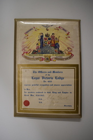
Certificate, Loyal Victoria Lodge, mid 1940s
The Loyal Victoria Lodge was established in Warrnambool in1862. It was a Lodge connected with the Friendly Society Manchester Unity Independent Order of Oddfellows. Friendly Societies were established to give members assistance in times of illness and hardship and to offer insurance against such events. The MUIOOF had its origins in Manchester, England. The Warrnambool Lodge built the Oddfellows Hall in Koroit Street in 1869 and in 1872 it joined with other friendly societies and established the Friendly Societies Park in Koroit Street. The MUIOOF joined with the Australian Natives Association and today the new name in Australian Unity. No details are available on W. A. McLean but the certificate indicates that he served his country during World War Two.This certificate is of considerable interest as the Loyal Victoria Lodge was a pioneer friendly society in Warrnambool with its history going back to 1862. It is also a good example of the certificates given to Warrnambool residents who had rendered significant war time service in World War Two.Framed Certificate featuring text and a coloured picture. The picture includes: a dove, five scrolls, a laurel wreath surrounding a globe, three women in long dresses, three young children, two stylised flower beds, rays of light, a hill and four coats of arms. It is covered with clear plastic with a metal back and metal prop. WARRNAMBOOL DISTRICT INDEPENDENT ORDER OF ODDFELLOWS IN VICTORIA MANCHESTER UNITY FRIENDLY SOCIETY. The Officers and Members of the Loyal Victoria Lodge No. 4835 express grateful recognition and sincere appreciation to Bro. W. A. McLean for services rendered to God, King and Empire in Great War, 1939- 1945. N.G.Chas Gerock V.G. F.J. Toogood Rob Fairbridge Secretary. a circular red seal. -
Federation University Historical Collection
Magazine - Booklet, Ballarat School of Mines Students' Magazine, 1944
List of Full Course Students' 1944, Editorial, News and Notes, Obituary, The Literary Society, Fumes from the Lab, Our Sojourn in Port Pirie, Arts & Crafts Gossip, Sport, Commercial Notes, The Junior Techs, List of Junior Technical School Students' 1944White, blue, green and gold soft covered magazine of 66 pages including advertisements. Artworks Mr Heseltine - By Ruth Mole Mack - By Beryl Grinter Frederick - By Beryl Grinter Stan - By Ruth Mole Scotty - By Joan Walter Jenko - By Ruth Mole Dagwood - By Ruth Mole Along the track - By Neville Reeve Kanga - By Ruth Mole Nev - By Ruth Mole Charlie - By Joan Walter Shergold - By Joan Walter Very friendly people at this beach, everyone's waving at me - By John Procter At the crest of the hill - By Joan Walter Joyce - By Beryl Grinter Mr Procter - By Ruth Mole Phyllis - By Neville Reeve Gwen - By Beryl Grinter Doreen - By William Bates Laurel - By Joan Walter Lorna - By Ruth Mole Ah! an important discovery! wireless poles on Mars - By Frank Daykin Barbara - By Joan Walter Winsome - By Beryl Grinter Kath - By Joan Walter Lola - By Ruth Mole Amy - By Beryl Grinter Laurel - By Beryl Grinter Gwen - By Beryl Grinter June - By Beryl Grinter Peggy - By Beatrice Burgess Winifred - By Ruth Mole Elaine - By M.D Iris - By Ruth Mole Iris - By Ruth Mole Isobel - By Joan Walter Betty - By Joan Walter Nancy - By Neville Reeve Charlie - By Ruth Mole Harold - By Joan Walter Sammy - By Joan Walter Brokie - By Ruth Mole Dick - By Joan Walter Mac - By Ruth Mole Mac - By Beryl Grinter Willie - By Beryl Grinter Deany - By Beryl Grinter Ducky - By Ruth Mole Fitzy - By Joan Walter ballarat school of mines, magazine, percival d. fisher, neville reeve, gwen spiers, p. marxsen, stanley c. sharp, john c. shergold, beatrice e. burgess, john g. procter, alan m. scott, w. reid, elsie coombs, laurence j. george, d. wise, robert j. mckenzie, marian a. beckwith, geoffrey biddington, thelma ellsworth, maxwell a. richards, norma eltringham, k. saunders, john a. mckenzie, beryl grinter, frank d. daykin, dawn wilson, ernest j. poppins, dr pound, mr mein, mr f. g. procter, joan t. walter, peter j. wilson, ruth mole, ian cooper, jack lannen, jack henderson, james duncan, alan wilson, j. baird, ian mclachlan, maxwell lawrence, ken palmer, joy martin, patricia allan, graham lawrie, kevin mclachlan, marion pearce, dimsey, vaughan, wilson, callister, max webster, stan lawrie, eric goon, m. collins, alan paganetti, robert tasman pound, william symons, f. neville. reeve, lester w. roffey, kevin j. whiter, john m. blainey, john middlin, roy e. mawby, phillip p. coulson, john w. jolly, kingsley r. bremmer, basil j. marshall, james s. owen, raymond g. mccahon, lindsay g. pattenden, david t. coburn, bruce j. linklater, muriel coultham, g. harrison, mr cornell, b. brookman, john l. lewis, valerie vickers, robert j. mcmenzie, betty law, miss king, mrs mcilvena, valerie ballinger, grace lawry, mina gallie, eloise prowse, lois strick, kenneth j. lindsay, r. eggleton, w. redfern, w. blundell, l. clifton, w. parker, r. fitzclarence, r. sargent, d. mclachlan, c. mouser, w. trevethan, d. hart, r. bennett, j. beecroft, r. ingleton, k. dean, w. young, b. holloway, w. coad, a. clark, k. innes, k. george, r. willian, j. heys, a. coad, l. dennis, p. banfield, g. pyke, j. humphrey, h. george, f. jacobson, f. savage, c. eltringham, i. scott, a. hughes, h. fumberger, a. smith, m. grinham, c. hoffman, r. swales, joan walter, william bates -
 Ballarat Heritage Services
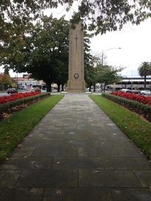
Photograph, Clare Gervasoni, Ballarat Cenotaph, 2015, 12/2015
A number of photographs of the Ballarat Cenotaph.ballarat cenotaph, world war, laurel -
 Ringwood RSL Sub-Branch
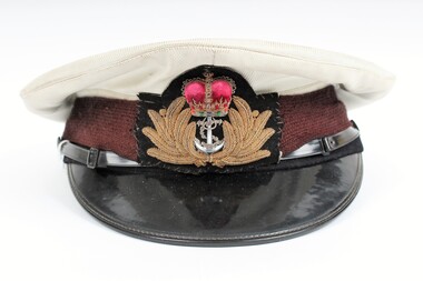
Memorabilia - Headgear, Hills Hats PTY. LTD, Naval Cap, 1981
White Cap, black rimmmed with gold laurel containing crown and anchor.Halls hats pty ltd Sydney 1981. RAN No. Name and “Made in NewZealand”; and indicates 6 and 7/8 inches hat size.ran, royal australian navy, naval headgear, navy cap -
 Whitehorse Historical Society Inc.
Document, Landscape Submission, c 1976
A landscape submission written for the National Trust of Australia (Victoria) for Blackburn Lake and the Bell Bird Streets.A landscape submission written for the National Trust of Australia (Victoria) for Blackburn Lake and the Bell Bird Streets. Definitions given of boundaries of the Lake area, ownership, housing and gardens. Photographs and map.A landscape submission written for the National Trust of Australia (Victoria) for Blackburn Lake and the Bell Bird Streets.blackburn lake sanctuary, waratah crescent, blackburn, jeffery street, hill street, boongarry avenue, linum street, laurel grove, acacia avenue, city of nunawading, melbourne and metropolitan board of works, furness park, camberwell grammar school -
 Whitehorse Historical Society Inc.
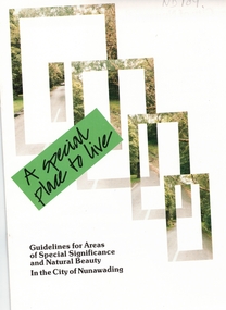
Pamphlet, A Special place to live, 1985 (addendum 1988)
A publication of the City of NunawadingA publication of the City of Nunawading explaining the regulations applying to the Special Residential (Nunawading) Zone No 5. The regulations cover proportions of land which may be built on and identifies trees which must be preserved. An addendum issued in 1988 includes a map of the area and identifies National Trust classified streets in Blackburn and the buffer areas in which less stringent regulations apply.A publication of the City of Nunawadingcity of nunawading, national trust of australia (victoria), special residential (nunawading) zone no. 5, jeffery street, blackburn, laurel grove, linum street, boongarry avenue, hill street, land use, by-laws, town planning, acacia avenue, waratah crescent -
 Flagstaff Hill Maritime Museum and Village
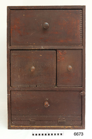
Furniture - Cupboard, c. 1890
The materials used to build the colonial cupboard have been gathered from various sources and recycled. In those days, it was normal to keep all manner of items 'just in case' they could be repurposed for another item. The brand "Laurel" on one of the wooden panels is from the Mobil Oil company's kerosene. There In the words of the donor, Betty Stone, "Made by Ellis Dale of Latrigg Wangoom, Warrnambool c 1890. The cupboard consists of packing cases stamped with original brand names. One drawer made from a gelignite packing case is of special significance as the Dale family owned a bluestone quarry known as The Dale Bluestone Quarries at Wangoom situated about three miles east of Warrnambool. Ellis Dale, second son of William Dale and Elizabeth (nee Chamberlain) Dale, was born in Wangoom, Warrnambool on 21 November 1860. His father, William Dale, a quarryman from Saddleworth, Yorkshire migrated to Australia in 1852; seven years later - in 1859- he purchased the quarries on twenty acres of land situated in Wangoom at the corner of what is now known as Dales and Aberline Roads. Later, when his two eldest sons, William Jnr and Ellis, reached ten or eleven years of age they worked with their father in the quarries. The work was arduous and dangerous as gelignite was used to blast the bluestone. In 1890 Ellis Dale married Ann Lees, daughter of Lees and Sarah (nee Chamberlain) Lees of Wangoom, Warrnambool. Initially Ellis and Ann Dale resided in a two roomed bluestone cottage which Ellis built a little further up the hill from his parents' home on the Dale family property. A few years later, in order to accommodate their growing family, additional rooms were added making a spacious, comfortable weatherboard home situated in Dales Road which they named Latrigg. Ellis Dale constructed this cupboard soon after he and Ann first set up home in their little stone cottage in 1890. When the home was rebuilt, the home-made cupboard was moved into the larger kitchen, and although Latrigg was well furnished, it remained in the corner between the kitchen door and the large wood stove where it served its purpose very well as it was used for storing ironing utensils. The lower compartment with the hinged drop-door was designed to store the flat irons which were heated on the wood stove, while the ironing blanket and cover, iron holders and other items were stored in the drawers. The Dale quarrying and contracting business existed in Wangoom, Warrnambool for over eighty years as after William Dale’s death. Ellis Dale together with his son lvor, continued on until he died in 1940. (Note: For additional information please refer to Betty Stone’s book “Pioneers and Places - A History of three Warrnambool Pioneering Families” i.e. Chamberlain, Dale and Lees Families)This item is associated with families of Chamberlain, Dale and Lees. These families are listed in the "Pioneers' Register" for Warrnambool Township and Shire, 1835-1900, published by A.I.G.S. Warrnambool Branch.Cupboard, rare example of a Colonial Cupboard, wooden. Made by Ellis Dale from packing cases; several brand names are evident inc. Gelignite and Laurel. Cupboard is lined with newspaper and wallpaper. Panels on left side are braced by attaching a metal scraper. Comprises four compartments, three have round wooden handles, lower compartment has a hinged, drop down door. (From the Chamberlain, Dale and Lees Collection)Brands on wooden panels of cupboard include "Gelignite" and "Laurel" (Laurel is a brand of kerosene)flagstaff hill, warrnambool, shipwrecked coast, flagstaff hill maritime museum, maritime museum, shipwreck coast, flagstaff hill maritime village, great ocean road, chamberlain, dale, lees, stone, betty stone, warrnambool pioneers, dale bluestone quarries, wangoom, cupboard, colonial cupboard, furniture, gelignite, packing crate, ellis dale, laurel -
 Flagstaff Hill Maritime Museum and Village
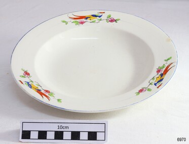
Domestic object - Plate, W. H. GRINDLEY & Co. Ltd, 1914-1925
The Maker’s Mark stamped on the back of this plate, a green laurel wreath with “W. H. Gringley & Co. Ltd, England” below, was used by the company between 1914-1925, according to Kroker and Goundry, authors of a paper “ARCHAEOLOGICAL MONITORING AND MITIGATION OF THE ASSINIBOINE RIVERFRONT QUAY”. The company used different Marks at other times during their operation. The design on this plate is transferware. The company used this more economical process of adding a transfer rather than employing artists to handprint them onto their dinnerware. William Henry Grindley and Alfred Meakin established the company at Tunstall, Stoke-on-Trent, in 1880. The company produced their wares for export to countries that included Australia.This ceramic plate is an example of dinnerware imported from England. The plate was made between 1914 and 1925 . The popular 'bird of paradise' design on the plate is an example of transferware, which made decorative dinnerware more affordable. China plate, earthenware, round, off-white colour with fine blue rim and three transfer decals spaced around the rim. Decals each have a bird of paradise on a flowering branch. The centre of the plate is plain. The maker’s stamp is an open green laurel wreath enclosing a decorative horizontal line, above the name. Made by W H Grindley & Co. Ltd of England.On underside; logo "[green wreath] above W. H. GRINDLEY & Co. Ltd. ENGLAND"flagstaff hill, warrnambool, shipwrecked coast, flagstaff hill maritime museum, maritime museum, shipwreck coast, flagstaff hill maritime village, great ocean road, plate, dinnerware, w. h. grindley, english, plateware, bird of paradise, transferware